Today, 17 August, marks the 250th anniversary of the first recorded ascent of Ben Nevis, by Edinburgh botanist James Robertson. I think. I say that because Wikipedia says it’s the 19th1Wikipedia Contributors (2021). Ben Nevis. [online] Wikipedia. Available at: https://en.wikipedia.org/wiki/Ben_Nevis?fbclid=IwAR3Xu-jc2FeDv–EnW_weSQQYyPZboZlUnolDM-c4ADfumiyYUO8xmNGlgE#History [Accessed 17 Aug. 2021].. Now, I can’t remember from where I acquired that snippet of information but the Nevis Landscape Partnership website says it’s the 17th, so that’s good enough for me2NEVIS LANDSCAPE PARTNERSHIP. (2021). Ben Nevis, Scotland’s National Mountain. [online] Available at: https://www.nevispartnership.co.uk/news/ben-nevis-scotlands-national-mountain [Accessed 17 Aug. 2021].. I haven’t the time on an evening to delve into things too deeply. In any case, I’m sure one of Bonnie Prince Charlie’s compatriots must have been up on the summit before that.
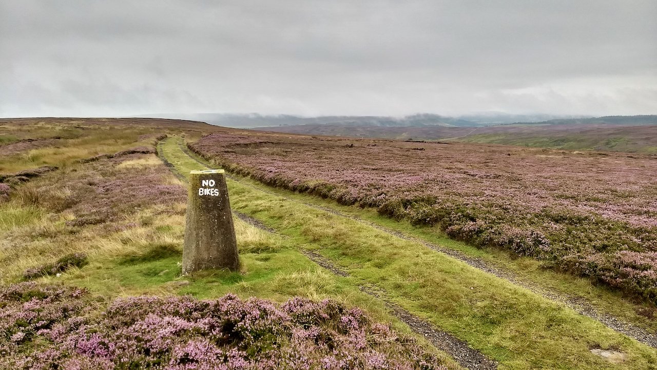
Ben Nevis, as the highest mountain in Britain, will have a trig. point on its summit, so short of a day trip up to the Highlands to photograph the mountain, today’s post is the trig. point on Gisborough Moor, which is of course connected to the Ben Nevis trig. point by a network of triangles.
The process of constructing trig. points on top of high points in the landscape began in 19353Wikipedia Contributors (2021). Triangulation station. [online] Wikipedia. Available at: https://en.wikipedia.org/wiki/Triangulation_station#United_Kingdom [Accessed 17 Aug. 2021].. By 1949, the actual process of surveying, or the “Retriangulation of Great Britain”, was ready to begin, no doubt interrupted by the war. Ben Nevis’s turn came in 19514“The History of the Retriangulation of Great Britain 1935-1962”. London: Her Majesty’s Stationary office. 1967. Available at: https://www.ordnancesurvey.co.uk/documents/resources/history-retriangulation-great-britain-1935-1962.pdf [Accessed 16 Aug. 2021]..
The “Retriangulation” survey for Ben Nevis was a mammoth task, requiring a seven-man team carrying 200 lbs of kit and equipment to the top of the summit every day for three weeks, leaving at seven o’clock in the evening and returning at five in the morning. It was a nightshift because a powerful search light was needed to be seen by the theodolites on neighbouring summits, Ben Lomond, Ben Lawyers, Ben Cruachan, and Ben Alder, where similar teams were employed. Some equipment, tents, stoves, cooking utensils, and so forth could be left on the summit during the day but the massive car batteries to power the light had to be taken down every day to be recharged5Ordnancesurvey.co.uk. (2015). Surveying Ben Nevis – The 49ers | Blog. [online] Available at: https://www.ordnancesurvey.co.uk/newsroom/blog/surveying-ben-nevis-the-49ers [Accessed 17 Aug. 2021]..
I guess a similar procedure would have been used here on Gisborough Moor but no doubt a tractor would have been utilised for hauling the kit.
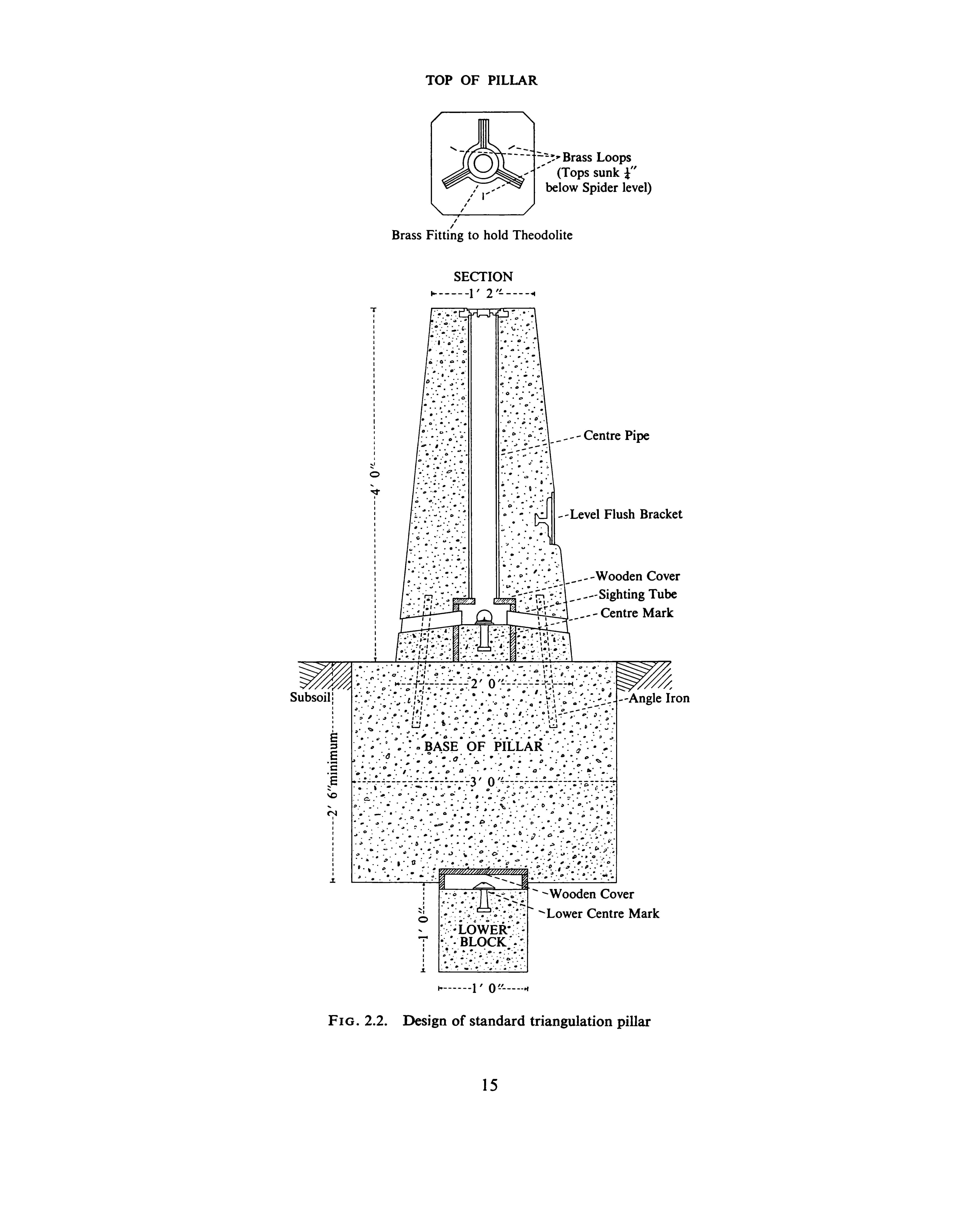
My wife, who was a surveyor for the Ordnance Survey, once told me that the actual mark for a trig. pillar is buried deep underground. Whenever I repeat this, it is often met with incredulity. In the document mentioned earlier, “The History of the Retriangulation of Great Britain 1935-1962″, I came across this cross-section of a trig. pillar which illustrates the construction.
The lower mark is a brass rivet set in a foot cube of concrete, 2′ 6” below the surface, and is the base for all measurements. It is covered by a wooden protective housing and a larger concrete block. At the base of the pillar is another brass rivet which is precisely referenced in respect to the lower one. The idea is that if the trig. pillar is damaged it can be dismantled and re-erected without disturbing the lower rivet.
The document “The History of the Retriangulation of Great Britain 1935-1962” is available here, but warning, it is a big pdf file and I do not advise downloading or reading on a phone. Starting from page 157 there are some interesting photos of trig. pillar construction and surveying.
- 1Wikipedia Contributors (2021). Ben Nevis. [online] Wikipedia. Available at: https://en.wikipedia.org/wiki/Ben_Nevis?fbclid=IwAR3Xu-jc2FeDv–EnW_weSQQYyPZboZlUnolDM-c4ADfumiyYUO8xmNGlgE#History [Accessed 17 Aug. 2021].
- 2NEVIS LANDSCAPE PARTNERSHIP. (2021). Ben Nevis, Scotland’s National Mountain. [online] Available at: https://www.nevispartnership.co.uk/news/ben-nevis-scotlands-national-mountain [Accessed 17 Aug. 2021].
- 3Wikipedia Contributors (2021). Triangulation station. [online] Wikipedia. Available at: https://en.wikipedia.org/wiki/Triangulation_station#United_Kingdom [Accessed 17 Aug. 2021].
- 4“The History of the Retriangulation of Great Britain 1935-1962”. London: Her Majesty’s Stationary office. 1967. Available at: https://www.ordnancesurvey.co.uk/documents/resources/history-retriangulation-great-britain-1935-1962.pdf [Accessed 16 Aug. 2021].
- 5Ordnancesurvey.co.uk. (2015). Surveying Ben Nevis – The 49ers | Blog. [online] Available at: https://www.ordnancesurvey.co.uk/newsroom/blog/surveying-ben-nevis-the-49ers [Accessed 17 Aug. 2021].
Leave a Reply