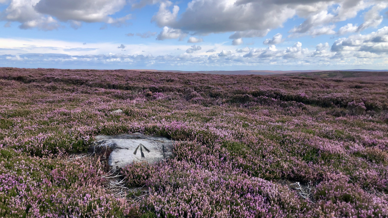
I unexpectedly stumbled upon this benchmark a week ago. And yesterday, seeking a breather after a gruelling climb from Hob Hole, I concealed my bike amidst the heather, then ambled a couple hundred metres to revisit it.
The mark, showing little sign of erosion, distinctly directs attention to a notch atop the boulder. Clearly an Ordnance Survey benchmark, though no longer of any use, their extensive registry of half a million such marks unveils several potential contenders for this one1‘OS-Net | Ordnance Survey’. 2021. Ordnancesurvey.co.uk (Ordnance Survey) <https://www.ordnancesurvey.co.uk/benchmarks/> [accessed 31 August 2023]:
| Square | Easting | Northing | Mark type | Description | Height | Order | Datum | Verified year | Metres above ground |
|---|---|---|---|---|---|---|---|---|---|
| NZ | 6428 | 0863 | PIVOT | PIVOT CUL NE SIDE RD | 280.995 | 3 | ‘N’ | 1953 | 0.100 |
| NZ | 6449 | 0833 | PIVOT | PIVOT ROCK 50.0M SE END BANK | 289.210 | 3 | ‘N’ | 1953 | 0.100 |
| NZ | 6475 | 0820 | CUT MARK | NBM STO NE SIDE RD | 283.019 | 3 | ‘N’ | 1953 | 0.400 |
| NZ | 6484 | 0807 | CUT MARK | NBM GTP 6.0M SE WALL JUNC NE SIDE RD | 273.250 | 3 | ‘N’ | 1953 | 0.400 |
My phone indicated the grid reference as NZ 6401 0842, which could mean it’s not that accurate; the Ordnance Survey chaps messed up; or someone fancied a game of boulder shuffle with a JCB.
By a process of elimination, I’ve deduced that this is likely the “PIVOT ROCK 50.0M SE END BANK.” There’s a website where benchmark enthusiasts record their conquests, and this one seems to have given them a real run for their money2Peattie, Ian. 2023. ‘Pivot: Kildale, Kildale Moor 289.2m’, Bench Mark Database (Bench Mark Database) <https://www.bench-marks.org.uk/bm114637> [accessed 31 August 2023].
Now, benchmarks are used in “levelling,” a process where points get an altitude label based on a known datum. Sea-level was elected as the datum because most land in the British Isles, not all mind you, sits a tad above the waves. So, it’s easier to think of everything as “up” or positive3Tim Owen & Elaine Pitman. “Ordnance Survey: Map Makers to Britain since 1791. Page 43. Crown copyright 1992..
Most people are familiar with the triangulation pillars that have been placed on many high hills. Any point within sight of two of these trig points can be plotted on a map by trigonometry.
But, here’s the catch – if those trig points were all at the same altitude, the maths would be easy. But they’re not! They stand tall at different heights. So, if we want to know how far they are from each other, we need to figure out their altitude. Enter levelling.
In the early days of the Ordnance Survey, there was a departmental banter going on between the trigonometrical observers and the levellers. The former bragged that the final map depended on their observations. The levellers said that while this was true, where would the trigonometrical observers’ accuracy have been without levelling.
So, the Ordnance Survey spent over two decades levelling the country with their telescopes, completing in 1860. But come the mid-20th century, someone spotted inconsistences in the survey. Turns out, the atmosphere messes with the readings — refraction. The longer the measurement, the bendier it gets. And moisture – that messes them up too.
So, in 1950, a revision was ordered4Ibid. Page 141.. This took until 1956 to complete in England, and our benchmark on Kildale Moor dates from this survey.
In a typical levelling operation, the surveyor placed a ‘stave’ on a point of known height, an existing bench-mark, and a forward stave on a new bench-mark some distance away but within sight. Using a telescope incorporating a spirit level between the two, the difference in height could be calculated. The surveyor leap-frogged along in this manner.
- 1‘OS-Net | Ordnance Survey’. 2021. Ordnancesurvey.co.uk (Ordnance Survey) <https://www.ordnancesurvey.co.uk/benchmarks/> [accessed 31 August 2023]
- 2Peattie, Ian. 2023. ‘Pivot: Kildale, Kildale Moor 289.2m’, Bench Mark Database (Bench Mark Database) <https://www.bench-marks.org.uk/bm114637> [accessed 31 August 2023]
- 3Tim Owen & Elaine Pitman. “Ordnance Survey: Map Makers to Britain since 1791. Page 43. Crown copyright 1992.
- 4Ibid. Page 141.
Leave a Reply