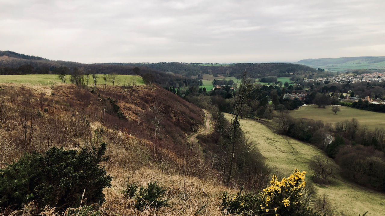
My plan was to take a photo of an old route from Guisborough climbing Kemplah Bank on to Hill Plain.
The pasture fields of Hill Plain can be seen in the top left corner, while Ruthergate is recognisable by the diagonal line of dark green gorse that stands out against the brown of the withered bracken. A standing stone used to be located where Ruthergate met the crest of the bank, just a little further from the group of beech trees1‘View Map: Ordnance Survey, Yorkshire 17 (Includes: Guisborough; Hutton Lowcross.) – Ordnance Survey Six-Inch England and Wales, 1842-1952’. 2023. Maps.nls.uk <https://maps.nls.uk/view/102344206#zoom=7&lat=2777&lon=8252&layers=BT> [accessed 4 March 2023].
Beginning at Hutton Lane, Ruthergate commences from the spot where the shaft of the former Ruther Cross still stands2‘Archaeology Data Service’. 2023. Archaeologydataservice.ac.uk <https://archaeologydataservice.ac.uk/archsearch/record?titleId=3378300> [accessed 4 March 2023]. It would have traversed a solidly constructed causeway across the boggy terrain, before embarking on the climb up Kemplah Bank3‘Heritage Gateway – Results’. 2023. Heritagegateway.org.uk <https://www.heritagegateway.org.uk/Gateway/Results_Single.aspx?uid=485da46c-ae7f-4c24-8092-6e85b0273799&resourceID=19191> [accessed 4 March 2023]. This pathway is still noticeable by a low embankment running along the boundary of the present residential area. Upon entering the woodland area at the base of the hill, the route is evident by a holloway, bordered by oak trees.
For a significant stretch, Ruthergate delineated the boundary of Guisborough with Hutton township, and is referenced in medieval charters, showing at times as “Rechergate” or “Rogergate“4“Guisborough Before 1900”. Edited by B.J.D. Harrison and G. Dixon. Page 71. 1982. ISBN 0 9507827 0 X.. There is a possibility that Ruthergate could be the “stone road“, which has led to the theory that its initial purpose was to serve a quarry on Highcliff. However, no concrete evidence has been found to confirm the existence of any such quarry on the escarpment.
Historical records from the 17th century mention Ruthergate. An edict issued by the Guisborough Court Leet orders that “the tenants of Hutton shall mend the way at Rothergate Lane“. Furthermore, in the 18th century, two diarists named Ralph Ward and Ralph Jackson recounted their experiences of descending from Highcliff using this route5“Guisborough Before 1900”. Edited by B.J.D. Harrison and G. Dixon. Page 71. 1982. ISBN 0 9507827 0 X..
The low-lying fields adjacent to the old route were referred to as Ruthergate closes, and it is possible that these fields were once used for loading and unloading, or as a resting place for the pack animals6Dixon, Grace. “Two Ancient Townships – Studies of Pinchinthorpe and Hutton Lowcross”. Page 44. ISBN 0 9507827 2 6 1991. Additionally, other intriguing remnants of the ancient road above High Plain can be discerned in holloways that cut across the fields and along the periphery of the woodland.
- 1‘View Map: Ordnance Survey, Yorkshire 17 (Includes: Guisborough; Hutton Lowcross.) – Ordnance Survey Six-Inch England and Wales, 1842-1952’. 2023. Maps.nls.uk <https://maps.nls.uk/view/102344206#zoom=7&lat=2777&lon=8252&layers=BT> [accessed 4 March 2023]
- 2‘Archaeology Data Service’. 2023. Archaeologydataservice.ac.uk <https://archaeologydataservice.ac.uk/archsearch/record?titleId=3378300> [accessed 4 March 2023]
- 3‘Heritage Gateway – Results’. 2023. Heritagegateway.org.uk <https://www.heritagegateway.org.uk/Gateway/Results_Single.aspx?uid=485da46c-ae7f-4c24-8092-6e85b0273799&resourceID=19191> [accessed 4 March 2023]
- 4“Guisborough Before 1900”. Edited by B.J.D. Harrison and G. Dixon. Page 71. 1982. ISBN 0 9507827 0 X.
- 5“Guisborough Before 1900”. Edited by B.J.D. Harrison and G. Dixon. Page 71. 1982. ISBN 0 9507827 0 X.
- 6Dixon, Grace. “Two Ancient Townships – Studies of Pinchinthorpe and Hutton Lowcross”. Page 44. ISBN 0 9507827 2 6 1991
Leave a Reply