I have often wondered what the old medieval roads across the moors were like. The temptation is to imagine they were similar to modern access roads but these have had the benefit of contemporary maintenance techniques with hydrocarbon fuelled machines. I think pot-holes and deep mud would have been the norm.
Route were north-south, following the natural lie of the land. Dale bottoms were avoided, steep slopes kept to a minimum. One source of danger to the lone traveller would have been wolves.
The old routes were used by pannier-trains and carts both two-wheeled ‘coups‘ or ‘cowps‘ or heavier four-wheeled wagons driven by oxen, or sheep and cattle would have been driven. This traffic would have led to a track of varying widths as users detoured around ruts and boggy patches1“The North York Moors Landscape Heritage”. Edited by D.A.Spratt and B.J.D.Harrison. David & Charles. ISBN 0 7153 93472 1989..
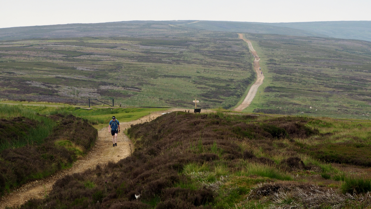
This track along Rudland Rigg is the modern incarnation of the medieval route south from Battersby Bank to Kirbymoorside. One source names it as the Waingate, and passes Cockan Cross2“Cockan Cross Wayside Cross 600m West of Fox Hole Crag, Bransdale – 1011747 | Historic England.” Historicengland.org.uk, 2012, historicengland.org.uk/listing/the-list/list-entry/1011747. Accessed 9 July 2021. and the pre-historic Cammon Stone3“Cammon Stone Standing Stone on Rudland Rigg 1030m NNE of Cockan Cross, Farndale West – 1019520 | Historic England.” Historicengland.org.uk, 2012, historicengland.org.uk/listing/the-list/list-entry/1019520. Accessed 9 July 2021. on its way down Rudland Rigg. From Battersby Bank, one destination could have been the Medieval market at Kildale4“Historical Atlas of North Yorkshire.” Edited by Robin A Butlin. Westbury Publishing. Reprinted 2004. ISBN 1 84103 023 6..
I have taken the photo from just south of the wayside cross known as the Jenny Bradley stone5“Wayside Cross Known as Jenny Bradley 1000m North West of Bloworth Crossing on Greenhow Moor, Ingleby Greenhow – 1010084 | Historic England.” Historicengland.org.uk, 2012, historicengland.org.uk/listing/the-list/list-entry/1010084. Accessed 9 July 2021.. In the near distance is Bloworth Crossing, where the old Rosedale ironstone railway crosses Rudland Rigg.
Several medieval routes traverse this area of moorland. Just a mile away is Round Hill on Urra Moor where the pannierway from Stokesley, Haggesgate turns south near the post-medieval Face Stone to follow Bransdale Ridge, Thurskilsti, for Beadlam where it meets the Helmsley to Pickering road, Sperragate.
There is also documented a packhorse way from the Cistercian nunnery at Baysdale Abbey to Rievaulx Abbey in Ryedale. Beyond the Jenny Bradley stone there is no obvious route. Even today, it would be quite a navigational challenge. I would tend towards picking up Thurskilsti and following that to the Stump Cross6“Wayside Cross Known as Stump Cross on Bransdale Ridge, Bilsdale Midcable – 1010347 | Historic England.” Historicengland.org.uk, 2012, historicengland.org.uk/listing/the-list/list-entry/1010347. Accessed 9 July 2021., from where I imagine a now forgotten route led across Bilsdale East Moor. Two medieval crosses, Roppa Cross7“Roppa South Cross on Carr Cote Ridge 1100m WSW of Piethorn, Helmsley – 1011746 | Historic England.” Historicengland.org.uk, 2012, historicengland.org.uk/listing/the-list/list-entry/1011746. Accessed 9 July 2021. and another un-named one8“Wayside Cross 950m East of Spout House Plantation, Helmsley – 1009370 | Historic England.” Historicengland.org.uk, 2012, historicengland.org.uk/listing/the-list/list-entry/1009370. Accessed 9 July 2021. sort of support this.
- 1“The North York Moors Landscape Heritage”. Edited by D.A.Spratt and B.J.D.Harrison. David & Charles. ISBN 0 7153 93472 1989.
- 2“Cockan Cross Wayside Cross 600m West of Fox Hole Crag, Bransdale – 1011747 | Historic England.” Historicengland.org.uk, 2012, historicengland.org.uk/listing/the-list/list-entry/1011747. Accessed 9 July 2021.
- 3“Cammon Stone Standing Stone on Rudland Rigg 1030m NNE of Cockan Cross, Farndale West – 1019520 | Historic England.” Historicengland.org.uk, 2012, historicengland.org.uk/listing/the-list/list-entry/1019520. Accessed 9 July 2021.
- 4“Historical Atlas of North Yorkshire.” Edited by Robin A Butlin. Westbury Publishing. Reprinted 2004. ISBN 1 84103 023 6.
- 5“Wayside Cross Known as Jenny Bradley 1000m North West of Bloworth Crossing on Greenhow Moor, Ingleby Greenhow – 1010084 | Historic England.” Historicengland.org.uk, 2012, historicengland.org.uk/listing/the-list/list-entry/1010084. Accessed 9 July 2021.
- 6“Wayside Cross Known as Stump Cross on Bransdale Ridge, Bilsdale Midcable – 1010347 | Historic England.” Historicengland.org.uk, 2012, historicengland.org.uk/listing/the-list/list-entry/1010347. Accessed 9 July 2021.
- 7“Roppa South Cross on Carr Cote Ridge 1100m WSW of Piethorn, Helmsley – 1011746 | Historic England.” Historicengland.org.uk, 2012, historicengland.org.uk/listing/the-list/list-entry/1011746. Accessed 9 July 2021.
- 8“Wayside Cross 950m East of Spout House Plantation, Helmsley – 1009370 | Historic England.” Historicengland.org.uk, 2012, historicengland.org.uk/listing/the-list/list-entry/1009370. Accessed 9 July 2021.
Leave a Reply