
I had hoped to photograph the tombolo that links the two high points of Bhatarsaigh—a narrow strip of machair, that low, sandy grassland so typical of the Outer Hebrides. But from the summit of Beinn Ruilibreac, I was just short of a clear view of the twin beaches that lie back to back on either side.
_JX286_Mar44_(16161355180)_(cropped).jpg)
Far off, Heabhal rises on Barra, the island’s highest hill. To its left stands Heiseabhal Beag. It was into this smaller hill that a Consolidated Catalina Mk. IVB, serial JX273, crashed on the night of 12 May 19441Clark, Alan. “Consolidated Catalina Mk.IVB JX273 of No.302 Ferry Training Unit flew into Theiseabhal Beag on Vatersay on the 12th May 1944”. Peak District Air Accident Research. 13, December, 2016. https://www.peakdistrictaircrashes.co.uk/crash_sites/scotland/consolidated-catalina-jx273-theiseabhal-beag-vatersay/.
The Catalina had taken off from Oban on a night navigation exercise, bound for Barra Head on Berneray, the southernmost of the Outer Hebrides. As they approached their turning point, the navigator realised they were off course and heading too far north. He told the pilot to climb to avoid the high ground ahead. The order came too late. The aircraft struck the upper slope of Heiseabhal Beag. Three crew members died in the crash or soon after. Locals cared for the survivors until help arrived from Barra by lifeboat.
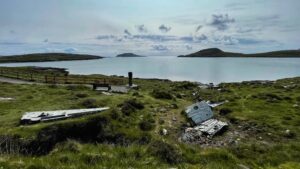
In July, an RAF base at Inverness sent a team of twelve to clear the wreck. They reached Castlebay, then crossed to Vatersay using private boats and the lifeboat. Over three weeks they dismantled the aircraft, salvaging weapons, engines, and electronic gear. The wings and hull were cut up, hauled downhill, and buried under boulders beside the road, where much of it still lies.
The Catalina was slow, awkward in the air, and hard to miss. Even so, it served across the world with many armed forces. Despite its age, some still fly today, repurposed as waterbombers against wildfires.
- 1Clark, Alan. “Consolidated Catalina Mk.IVB JX273 of No.302 Ferry Training Unit flew into Theiseabhal Beag on Vatersay on the 12th May 1944”. Peak District Air Accident Research. 13, December, 2016. https://www.peakdistrictaircrashes.co.uk/crash_sites/scotland/consolidated-catalina-jx273-theiseabhal-beag-vatersay/
Leave a Reply