Out & About …

… on the North York Moors, or wherever I happen to be.

Codhill Heights — Celtic origins in Yorkshire’s landscape

I read once that place-names split neatly into two groups: habitative names, describing the kind of settlement in question, and topographic names, painting a picture of the lay of the land — rivers, rocks, marshes, and hills. Among the ancient Celtic place-names that have trickled down to us, habitative names are not easy to find; it’s mostly topographic all the way.

Take Yorkshire, for instance. Its rivers sport names deeply rooted in the Celtic language. Hereabouts, we’ve got the Esk, Derwent, Leven, and the Tame. As for the hills, ‘pen’ is a popular element, signalling a sharp summit, like Pen-y-ghent, while ‘bryn’ suggests a gentler, rounded peak. The closest example of this I can find is Tidy Brown Hill up on Ingleby Moor.

Celtic names hinting at woodland origins are quite common, but they’re no evidence for proving the existence of ancient forests. Over time, words can get mangled through use and have more than one origin. Still, when you stumble upon names hinting at ancient woodland nearby – like ‘wudu’, ‘weald’, ‘hyrst’, and ‘coed’ – it sets the imagination alight. Even ‘leah’, indicating a clearing, implies the presence of nearby woodland.

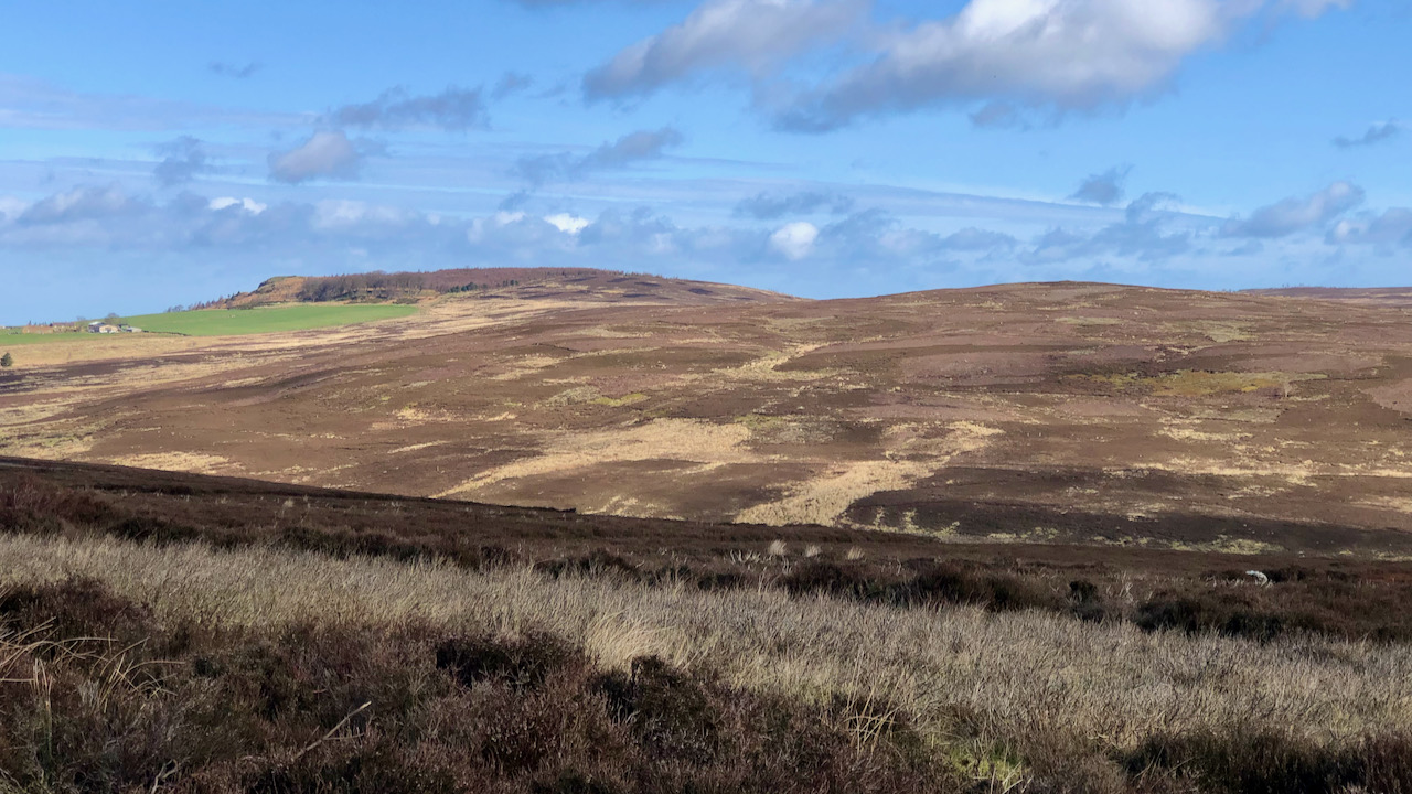
Now, that word, ‘Coed’, has folks suggesting it might be the root of the name Codhill Heights, the flat high point on the right in today’s featured image1Hudson, Martyn. “on blackamoor”. Page 88. 2020. ISBN 978-1-9164257-9-8.. It’s a stretch to picture a woodland cloak draping this ridge back in the Iron Age.

But there’s another theory in the mix. Some reckon ‘cod’ could trace its lineage back to the Norse word ‘keld’, meaning ‘spring’2Burns, Tom Scott. The Walker’s Guide to the Cleveland Hills. Page 49-50. 1993. Smith Settle.. And wouldn’t you know it, a spring did once bubble forth near the corner of that green field below Highcliff Nab on the left of the photo. It’s even named as Codhill Spring on the Victorian O.S. map.

That map also names what’s now Highcliffe Farm as ‘Cod Hill’, hinting that the name might’ve stretched to cover the whole area of what’s now the farm. And in a lease dating back to Henry VIII’s day, there’s mention of a close of land known as Coddale, which some suggest is a precursor of Cod Hill3“Guisborough Before 1900”. Edited by B.J.D. Harrison and G. Dixon. Page 71. 1982. ISBN 0 9507827 0 X.. In my imagintion, I see it pronounced as ‘Coddle’ in the Cleveland dialect, which the southern Victorian surveyor could have misheard as ‘Cod Hill’.

So, whether it’s ‘coed’ or ‘keld’, it’s all academic. Maybe Codhill Heights never wore a woodland crown after all.

  • 1
    Hudson, Martyn. “on blackamoor”. Page 88. 2020. ISBN 978-1-9164257-9-8.
  • 2
    Burns, Tom Scott. The Walker’s Guide to the Cleveland Hills. Page 49-50. 1993. Smith Settle.
  • 3
    “Guisborough Before 1900”. Edited by B.J.D. Harrison and G. Dixon. Page 71. 1982. ISBN 0 9507827 0 X.

Posted

in

, ,

by

Tags:

Comments

4 responses to “Codhill Heights — Celtic origins in Yorkshire’s landscape”

  1. Martin Smith avatar

    Highcliffe Farm was origionally Codhill Farm…we had it 1945- c. 2002

    1. Fhithich avatar
      Fhithich

      Quite. But I am more inclined to favour an original name of Coddale.

  2. Nancy (Potter) Halliday avatar
    Nancy (Potter) Halliday

    I think you may have solved my mysterious “kettle hill” / keldhill / Kelddale”!

    Prior to his death in 1747, a Ralph Potter was an occupier of “Kettle Hill” purchased for him by his nephew William Potter from George Lee (per his will). This would explain the land being “tithe free”, and the “Potters’ Ridge”.

    Therefore I think the farm was occupied by Potters from before 1747 – 1812. Above William’s son took over – then his son William.

    Around 1806/7 – This William (from Kettle Hills) purchased a property corner of Belmangate /Bow Street, and his son Ralph (and Jane) Potter took over the farm 1806-1812.

    I am a direct descendant from Ralph & Jane.

    Martin – nice to meet a caretaker of the farm! You may have met some of my ancestors that visited the farm shortly after the war. My father and I visited in 2006.

    If I could only find someone who is familiar with the Lee holdings around Hutton / Pinchenthorpe to confirm the sale.

    1. Fhithich avatar
      Fhithich

      Nancy, I am not so sure. I have a booklet by a local historian: Dixon, Grace. “Two Ancient Townships – Studies of Pinchinthorpe and Hutton Lowcross”. ISBN 0 9507827 2 6 1991, which says, on page 67, that Ralph Potter became the owner of Codhill in 1806. There is no record of kettle hill / keldhill / Kelddale in this or her other book on the history of Guisborough.

      Elsewhere in the book, on the other of the two townships, Pinchinthorpe, it says that George Lee was the eldest son and heir to Roger Lee but died in 1703 — Roger himself died in 1719.

      Here is a transcript of the relevant page (67) in the book:

      From the mid 16th mid century the eastern side of Hutton remained with the newly formed Chaloner estate. Their land extended south from the old Guisborough to Hutton road and included lowland of about 100 acres, the steep hillside of Kemplah Bank with the closes on its summit, then an upland farm of 130 acres, Codhill, later called Highcliff Farm. Beyond that stretched Guisborough Moor. The lower farmland was separated from Guisorough township by a narrow fringe of Crown land adjoining Ruthergate as already described. Little is known of these Chaloner areas in the two centuries following the Dissolution except that some land mentioned at Hutton in a 1602 survey may later have become Codhill farm. Highcliff Farm is thought to include some building structure dating from the early 18th century. Chaloner Occupation Books and Estate Maps of the late 18th century[1] together with Land Tax records[2] help to identify these farms. The lowland area was farmed in turn by John Lincoln then by Robert Thomas, the latter also farming some Crown land in Hutton. Codhill Farm was occupied by William Waller.

      In 1806 Robert Chaloner sold both farms to Joseph Hickson, his agent,[3] and
      thereafter the histories of the two farms separated. Ralph Potter of Girrick, Moorsholm, became the owner of Codhill in 1806,[4] but remained heavily in debt to Joseph Hickson. Although the 1811 Crown Survey of Hutton was not concerned with Chaloner land there was a footnote given:—
      
”Mr. Joseph Hickson has a farm consisting of 60-70 acres of low land besides banks and waste in Hooton lordship, his own freehold estate purchased by him of Mr. Challoner. He sold off 100 acres of moorish land to Ralph Potter. Mr. Hickson and Potter claim their estate to be tyth free.”[5]
      
This was a correct claim as the land had been part of the.demesnes of Guisborough Priory. In the 1845 Tithe Award no tithe was payable on this former Chaloner land.[6]

      The occupants of both Chaloner farms had the right to take water from Codhill spring “in Highcliff Nab field near a gate going to the moor”. They could also take stones from Highcliff and use the centuries old rights of common pasture on the Hutton Moor.[4] Land owners of the early 19th century continued to send sheep to Hutton Moor in order to retain this old right. The 1856 Ordnance Survey Map shows the Codhill Spring which can even now be located, and may be the ‘Thruhkelde’ of the medieval charters. Above this the high moorland stretching from Highcliff to Codhill Heights is named ‘Potter’s Ridge.’

      It appeared that Ralph Potter had not farmed very successfully. In 1810 probably to lessen his debt on Codhill he had sold Armstrong Banks Close which was next to the Chaloner boundary, to Robert Chaloner. However in 1812 he was obliged to quit the farm and was later living in Ayton. His eldest son, William, remained in Hutton and Guisborough as described in the Chapter on the Crown land. Codhill farm was sold in 1812 to J.Ridley of Ayton[7] but in 1820 was resold to William Powell.[8]


      Footnotes
      1. North Yorks Record Office. Z F M Chaloner Occupation Books.

      2. Cleveland County Archives. Land Tax records for Langbaurgh East, 1780-1830.
      3. N.Y.RO. Registry ofDeeds 1808. DE 452.

      4. N.Y.RO. Registry ofDeeds 1807. DE 39.

      5. Borthwick Institute, York. C C Ab 7 Rentals and Surveys.

      6. N.Y.RO. Z FM 1845 Tithe Map and Award for Hutton.
      7. N.Y.RO. Registry of Deeds. 1813. D Q 489.
A grandson of Ralph Potter emigrated to Canada in the 1840s, but descendants still keep a keen interest in Guisborough and Hutton.

      8. N.Y.R.O. Registry of Deeds. 1820 E L 427.

      Good luck!

Leave a Reply

Your email address will not be published. Required fields are marked *