The recognition of a clustering of rock-art sites around the perimeter of Scugdale has given rise to a hypothesis concerning a plausible ancient prehistoric route encircling the valley. This period corresponds to approximately 5,000 years ago, specifically the Middle Neolithic era, when Scugdale likely comprised a blend of thick woodland and the marshy vestiges of a glacial lake impounded by ice.
Dubbed the ‘Scugdale Loop’, it follows an anticlockwise circuit, skirting the periphery of Scugdale. At pivotal junctures along this prehistoric ‘long distance footpath’, there are four conspicuous large round cairns. While traditionally associated with funeral rites, these structures may also have served as notable landmarks. Three of these cairns share a distinct feature, offering an unobstructed view towards Roseberry Topping—Prod Howe, Barker’s Ridge, and Stone Ruck. Meanwhile, the fourth cairn, on Far Moor, directs attention towards Whorl Hill. While commonly attributed to the early Bronze Age, it’s plausible that these round cairns originated as Neolithic constructs, strategically positioned in these carefully selected sites1Smith, Brian A., Ken W. Grant, and Alan A. Walker. “Cairns as waymarkers within a proposed prehistoric Scugdale ‘Loop’”. TEESSIDE ARCHAEOLOGICAL SOCIETY Bulletin Number 18. 2013..
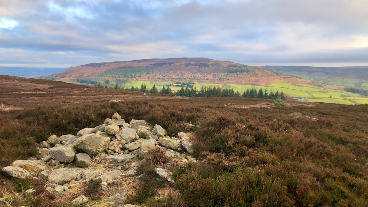
The final round cairn in this series is situated atop Stone Ruck, now adorned with a heap of stones2North York Moors Historic Environment Record (HER) No: 2082. Round cairn at Stone Ruck BRONZE AGE (2600 BC to 700 BC). Despite this heap’s relatively recent construction, the name ‘ruck’ likely finds its roots in the Yorkshire vernacular, denoting a mound or heap, be it of stones, turf, or hay3York.ac.uk. (2021). ruck – Yorkshire Historical Dictionary. [online] Available at: https://yorkshiredictionary.york.ac.uk/words/ruck [Accessed 2 Oct. 2021]..
And lo-and-behold, upon arriving at the cairn, Roseberry reveals itself in the sightline to the northeast, peering over the western shoulder of Cringle Moor.
Significantly, there are no substantial round cairns between the Barker’s Ridge cairn and this one, spanning a distance of 2½ kilometres, between which Roseberry is concealed by the bulk of Cringle Moor.
If the hypothesis holds water and this Scugdale Loop indeed evolved during the Neolithic, we’re staring at quite an extensive region of ritualised landscape. The rock-art sites, dispersed strategically along the envisioned ‘loop,’ indicate the existence of such a Neolithic route. The carved motifs on these rocks predominantly feature cups or more expansive basins, often accompanied by artificial grooves. Certain carvings seem linked to water-flow characteristics initially shaped by exposure to the elements. The prevailing agreement is that the lion’s share of this rock-art aligns with a Neolithic time period.
- 1Smith, Brian A., Ken W. Grant, and Alan A. Walker. “Cairns as waymarkers within a proposed prehistoric Scugdale ‘Loop’”. TEESSIDE ARCHAEOLOGICAL SOCIETY Bulletin Number 18. 2013.
- 2North York Moors Historic Environment Record (HER) No: 2082. Round cairn at Stone Ruck BRONZE AGE (2600 BC to 700 BC)
- 3York.ac.uk. (2021). ruck – Yorkshire Historical Dictionary. [online] Available at: https://yorkshiredictionary.york.ac.uk/words/ruck [Accessed 2 Oct. 2021].
Leave a Reply