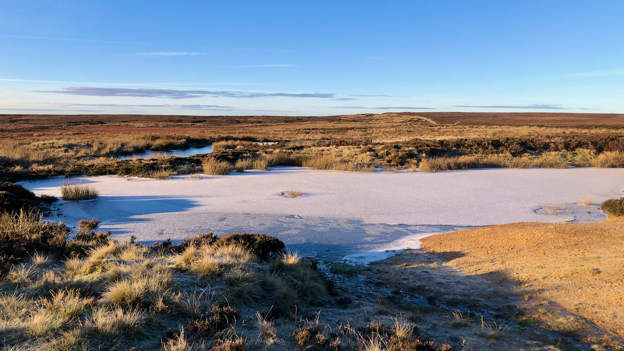
I took this photograph with an eye toward history. It’s a scene on the brink of transformation.
A couple of frozen ponds glisten at the low point between Round Hill and Badger Gill on Urra Moor. They drain southward into Hodge Beck—Bransdale. The Cleveland Way stands out as it crests the hill, slightly to the right of centre, and skirts around the ponds, making its way eastward to Bloworth Crossing.
Before long, from this very spot, that segment of the Cleveland Way will vanish behind a 20-metre tall mobile phone mast, decked out with antennas, dishes, and remote radio heads. The setup will include ground-based paraphernalia like a generator cabinet, all enclosed by perimeter fencing and a solid hardstanding. The total area: 0.1 hectares or 0.25 acres, roughly an eighth of a football pitch in that universal scale1Online Standard Details’. 2023. Northyorkmoors.org.uk <http://planning.northyorkmoors.org.uk/Northgate/PlanningExplorer/Generic/StdDetails.aspx?PT=Planning%20Applications%20On-Line&TYPE=PL/PlanningPK.xml&PARAM0=818942&XSLT=/Northgate/PlanningExplorer/SiteFiles/Skins/NorthYorkMoors/xslt/PL/PLDetails.xslt&FT=Planning%20Application%20Details&PUBLIC=Y&XMLSIDE=/Northgate/PlanningExplorer/SiteFiles/Skins/NorthYorkMoors/Menus/PL.xml&DAURI=PLANNING> [accessed 29 November 2023].
This mast, serving Virgin/O2, aims to enhance 4G connectivity for Stokesley and a sweep of villages: Ingleby Greenhow, Easby, Battersby, and Great Broughton. Additionally, the coverage will extend to scattered rural farms and houses, along with footpaths, bridleways, and public roads within the National Park. Access for construction will be via the Baysdale road.
In 1962, Bill Cowley, a farmer and historian from Cleveland, best known as the architect of the Lyke Wake Walk, saw his letter published in The Times newspaper2COWLEY, W. “Where To Walk?” Times, 12 May 1961, p. 17. The Times Digital Archive, link-gale-com.ezproxy.is.ed.ac.uk/apps/doc/CS287531180/GDCS?u=ed_itw&sid=bookmark-GDCS&xid=3ffeaa7a. Accessed 27 June 2021.:—
WHERE TO WALK?
Sir,-Across the North York Moors at their highest and widest point goes a fine long-distance walk – 40 miles of rough moor with scarcely a human habitation on the route until recently. The Early Warning Station of Fylingdales has been placed right across one end of this route. Along the northern scarp of the Cleveland Hills afforestation is everywhere in progress, and tracks which once were open are now confined by wire fences. On Urra Moor (1,490ft.) on the Feversham Estate firebreaks have been gouged out of the moor, and bulldozers have buried or torn up parts of a flagged causeway, one of our few surviving pack-horse tracks. It is in despair that walkers who love the wild places of England as they are – or were – plead for some real powers of control to be exercised by the National Parks Commission.I am, Sir, yours faithfully,
W. COWLEY.
Potto Hill Farm, Swainby, Northallerton, May 10.
Today, the Cleveland Way follows one of these “firebreaks” that Cowley speaks of. It is an utterly tedious section of the National Trail, yet it is all I have ever known. What a crossing of Urra Moor would be like using the old “flagged causeway” is beyond my imagination.
I must concede to harbouring a certain ambivalence. The conveniences of a rural mobile network, I presume, will outweigh the ugliness of an obtrusive mast and the loss of a SSSI moorland habitat. The erection of these structures is propelled by the imperatives of our contemporary way of life. Of course, it remains plausible that their permanence is not assured. Perhaps, in a few decades, it is within the realm of possibility that Elon Musk’s Starlink system will have asserted global dominance, rendering these masts obsolete. Consequently, walkers may find themselves lamenting the demise of these relics of industrial antiquity as I do the golf balls of Fylingdales. And of course, the scars left behind will eventually heal and perhaps the curlew, lapwing and merlin that have been evicted will return.
What would Bill Cowley have thought?
- 1Online Standard Details’. 2023. Northyorkmoors.org.uk <http://planning.northyorkmoors.org.uk/Northgate/PlanningExplorer/Generic/StdDetails.aspx?PT=Planning%20Applications%20On-Line&TYPE=PL/PlanningPK.xml&PARAM0=818942&XSLT=/Northgate/PlanningExplorer/SiteFiles/Skins/NorthYorkMoors/xslt/PL/PLDetails.xslt&FT=Planning%20Application%20Details&PUBLIC=Y&XMLSIDE=/Northgate/PlanningExplorer/SiteFiles/Skins/NorthYorkMoors/Menus/PL.xml&DAURI=PLANNING> [accessed 29 November 2023]
- 2COWLEY, W. “Where To Walk?” Times, 12 May 1961, p. 17. The Times Digital Archive, link-gale-com.ezproxy.is.ed.ac.uk/apps/doc/CS287531180/GDCS?u=ed_itw&sid=bookmark-GDCS&xid=3ffeaa7a. Accessed 27 June 2021.
Leave a Reply