On this day in the year 1845, Parliament passed the Inclosure Act 1845, an ominous piece of legislation that concluded a grim transformation to the country1‘Inclosure Act 1845’. 2014. Legislation.gov.uk <https://www.legislation.gov.uk/ukpga/Vict/8-9/118> [accessed 7 August 2023]. This Act, a tool of the powerful, wrested away the public land and enshrined the authority of enclosure commissioners, who, free from the yoke of parliamentary scrutiny, could enclose yet more land. This nefarious practice of enclosure, spanning from the 17th to the 20th centuries, resulting in the passing of more than 5,000 enclosure acts, fencing off a staggering expanse of 6.8 million acres of communal land. Military force was often unhesitatingly used upon those valiant enough to resist. The enclosures were a tentative step in the relentless growth of modern capitalism, as they created an entire class of landless people who had no way of surviving other than by selling their labour — the working class.
Great Ayton’s once open fields and commons had already been consigned to the annals of history in 1658. The major landowners of the village, men like John Coulson, James Stockton, and Sir John Lowther, colluded to enclose the village lands. Naturally, the division was tipped in their favour, as Coulson claimed the lion’s share – a sprawling 1469 acres – dwarfing Stockton’s modest 111 acres2o’Sullivan, Dan. “Great Ayton: A history of the village”. Page 47/8. 1983..
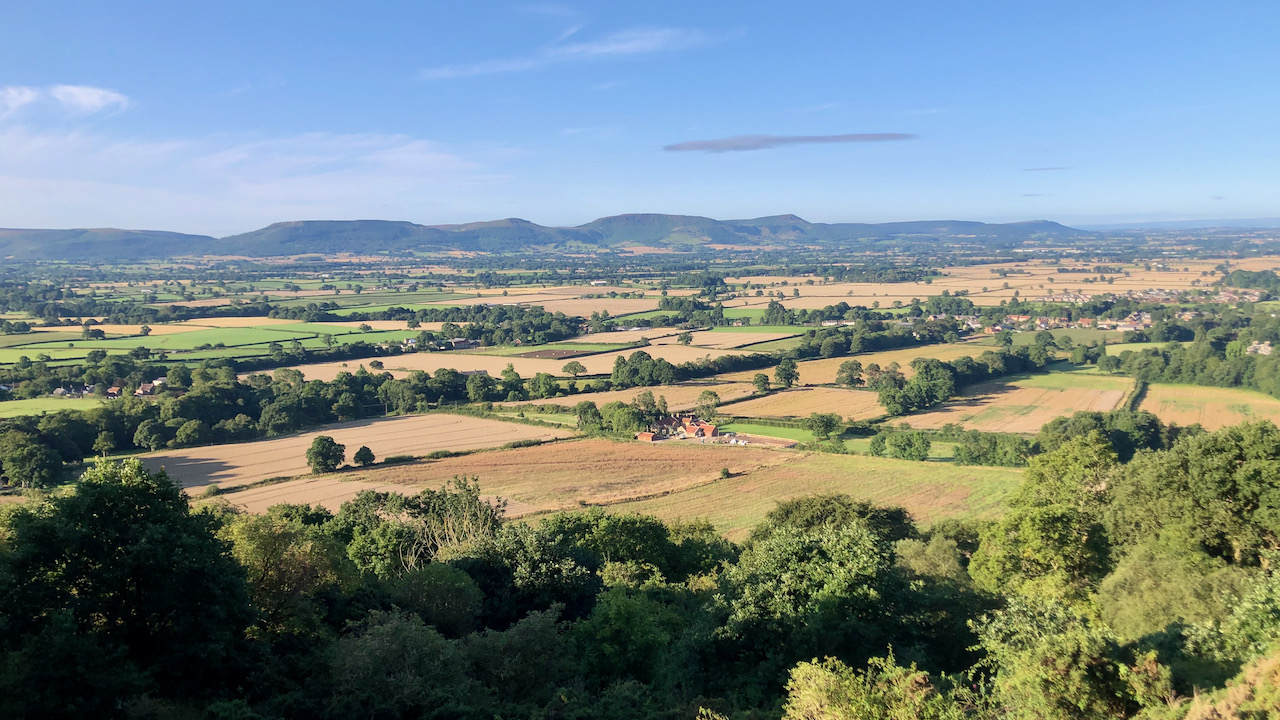
Three open fields once enveloped the village, each of several hundred acres. Applebridge Field lay to the southwest, with Crabtree Field in the northwest. The third, Woodfield, nestled beneath Cliff Rigg, to the northeast. These open fields were divided into smaller units, named furlongs, which were split into strips, each strip being tended by an individual villager.
In the photograph, Rye Hill farm is at the centre. The fields, to its right, are part of Woodfield. To its left was a slender ribbon of Commons, called Dikes, a name which has persisted through the ages as Dyke Lane. Beyond Dyke Lane lies the manor of Little Ayton. A modern hedge is a living marker of the boundary between Woodfield and Dikes.
After enclosure, for those fortunate enough to receive a substantial holding of land, the natural thing to do was to erect a farmhouse, away from the village’s centre. This is the origin of many local farms, with buildings first built in the 18th century. Very few of these farmsteads, if any, existed before the late 17th century.
Simultaneously, the Common land, that shared land that once surrounded the village, such as Aireyholme and Banks, was enclosed. Those disenfranchised villagers, robbed of their birthright to till the Open Fields, and no longer allowed to use the Commons, stood at a crossroads. Either be condemned to a life of servitude as an agricultural labourer, or leave the village and head for the factories and mines in the growing urban towns and cities.
Through the course of a few centuries, a sweeping transformation had reshaped the English landscape. The vast expanse of Britain’s land, once under the banner of communal stewardship, has undergone a remarkable shift – a shift into the grasp of singular landowners. Today, within our “property-owning democracy,” a mere fraction of the population, a scant 0.06%, comprising 40,000 wealthy land barons, lay claim to nearly half the nation’s land. Meanwhile, the majority of us, toiling away for the better part of our working lives, find ourselves having to negotiate a cycle of debt as we labour away for a paltry plot scarcely big enough for our humble abode3‘A Short History of Enclosure in Britain’. 2017. Libcom.org <https://libcom.org/article/short-history-enclosure-britain> [accessed 8 August 2023].
- 1‘Inclosure Act 1845’. 2014. Legislation.gov.uk <https://www.legislation.gov.uk/ukpga/Vict/8-9/118> [accessed 7 August 2023]
- 2o’Sullivan, Dan. “Great Ayton: A history of the village”. Page 47/8. 1983.
- 3‘A Short History of Enclosure in Britain’. 2017. Libcom.org <https://libcom.org/article/short-history-enclosure-britain> [accessed 8 August 2023]
Leave a Reply