Out & About …

… on the North York Moors, or wherever I happen to be.

A view looking down on Sheepwash, where the ancient track known as the Hambleton Drove Road fords Crabtree. A metalled road leads from Scarth Nick pass, left of centre, and exits left to Osmotherley. The muted winter browns of dead bracken dominate the hillsides. A grassy path climbs the hill opposite.

An earlyish wander around Scarth Wood Moor

Overcast with a patch of heavy drizzle.

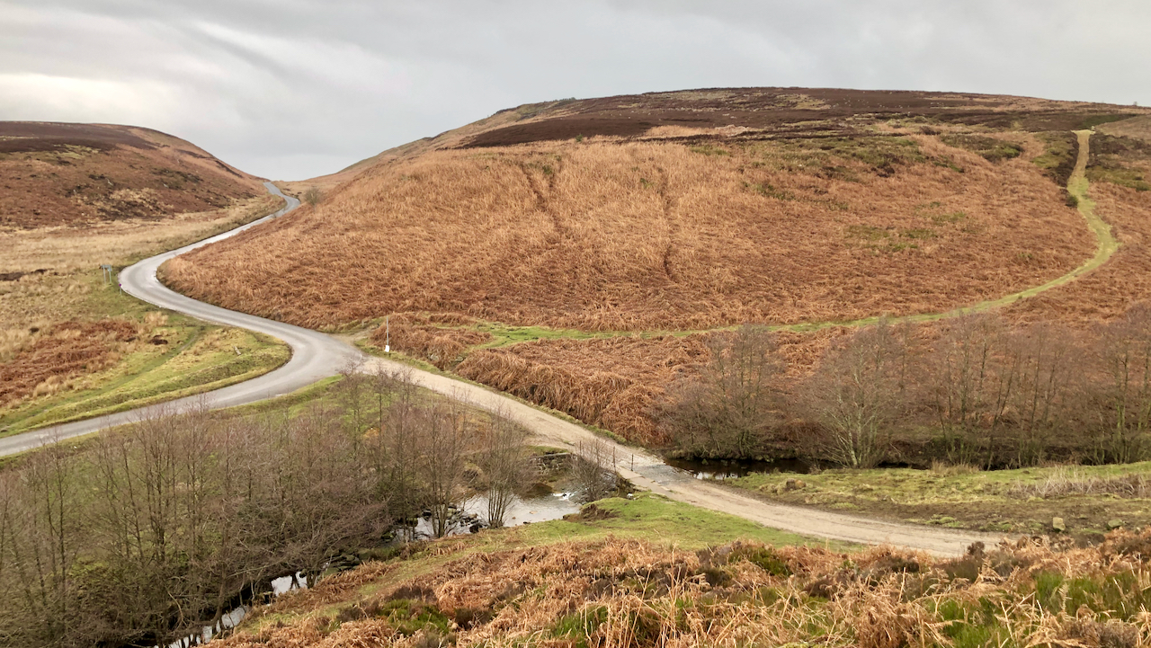
This is the famous Sheepwash. Where the Hambleton Drove Road fords Crabtree Beck. A popular honeypot in the post-war car boom, but that was before the Cod Beck Reservoir was built.

The grassy footpath opposite is not shown on the O.S. map as a Right of Way, but I am pleased to see that an Application for a Definitive Map Modification Order for it to be added to the Definitive Map as a “Restricted ByWay” along with other tracks in Clain Wood is progressing.

Photo of notice showing new "Restricted Byways".
Notice showing the new “Restricted Byways” annotated by the symbol “-∨-∨-∨-∨-“.

I knew about the application, made pre-Covid, but a notice advising the public is now affixed to the signpost — dated 16 December 2022. Objections closed on the 10th February.

The grassy path skirts a nose called Red Way Head, and joins the route of a track which is still mapped as Red Way. It climbs less steeply and its route can be made out contouring up from the Scarth Nick metalled road. This is clearer on the 1856 O.S. Map which demonstrates the route is a pretty old one.

As I understand it, these DMMOs do not to change any rights but simply recognise what already rights already exist and merely prove that the Definitive Map has an error or omission.

So at some point, when this DMMO is “confirmed”, the council, or in this case the National Park, will update the [paper] Definitive Map in their possession, followed, at some other point in time, by any online versions, and, at another point in time, advise the Ordnance Survey who may include the amendment in their next map update.

Don’t hold your breath.


Posted

in

, ,

by

Comments

3 responses to “An earlyish wander around Scarth Wood Moor”

  1. Janet Cochrane avatar
    Janet Cochrane

    Hi – an interesting post, as ever, but just to correct your impression of DMMOs: once the order is made, they do indeed change the rights to use a path. Historic rights may have existed in many cases, but it is usually up to the applicant to prove whether these were for foot traffic only or for horses – and in the meantime if the track is on private land and not a designated right-of-way, members of the public do not have a right to use it.
    People get alarmed by the term ‘Restrictive Byway’ as they assume that trail-bikes may soon be zooming along them. In fact, the only difference between Restrictive Byways and Bridleways is that horse-drawn carriages may use them in addition to pedestrians, horse-riders and cyclists – motorised traffic isn’t permitted (though unfortunately this is often ignored). There is often a presumption that new rights-of-way will be designated as Restricted Byways.
    Also, it is the Council which holds the Definitive Map (in this case North Yorkshire), not the National Park. The OS is pretty good at checking on changes to the definitive maps and will reflect the changed status in new editions of their printed maps, and sooner in the online version.

  2. Fhithich avatar
    Fhithich

    Thanks for that information, Janet. My understanding came from a order issued in 2016 for a footpath in Kildale which, as far as I know, is still not shown on the O.S. online mapping as a Right of Way and still signposted as a “Permissive Path. See https://assets.publishing.service.gov.uk/government/uploads/system/uploads/attachment_data/file/576202/fps_p2745_14a_5_decision.pdf

  3. Fhithich avatar
    Fhithich

    I have had further clarification. My understanding now (and I’ve done a lot of cutting and pasting here) is that the County Council has backed the Parish Council’s claim and has “confirmed the order”. This means that they agree with the evidence and want to make the routes into RoWs. Notices were posted by the County to invite anyone to object before they are officially added to the Definitive Map. It’s timed out now, but the landowners did object so now there has to be a Public Inquiry in front of an independent Planning Inspector who will make the final decision.

    The Inquiry is likely to be held in Stokesley Town Hall over two days and probably at the back end of this year(2023) or sometime next. Having approved the claim, the County now takes over the procedure and they intend to employ legal representation to assist. The Parish Council has approved commissioning a consultant specifically to assist as well.

    It’ll be a slow process. After the Inquiry we can expect probably another 6 months before the Inspector’s decision. They could approve all the routes, only some, or none at all.

Leave a Reply

Your email address will not be published. Required fields are marked *