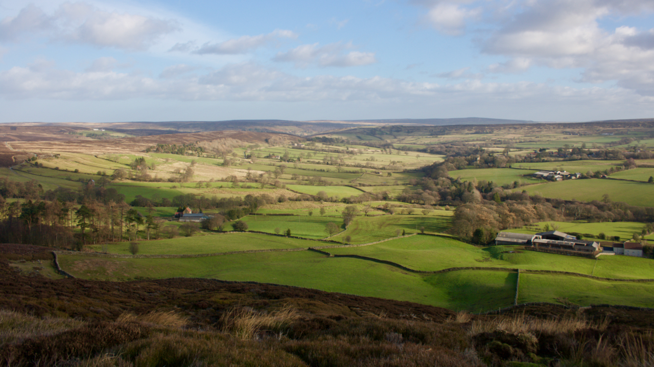
An unfamiliar view of the lower portion of Westerdale, taken whilst being buffeted by Storm Malik, the latest of this winter’s storm.
I am on what is named as Grange Bank on the old O.S. map descending into the dale after a slog over Baysdale Moor1Maps.nls.uk. (2022). View map: Yorkshire 44 (includes: Danby; Glaisdale.) – Ordnance Survey Six-inch England and Wales, 1842-1952. [online] Available at: https://maps.nls.uk/view/102344296#zoom=6&lat=9125&lon=1238&layers=BT [Accessed 29 Jan. 2022]..
The photo gives a good overview of the medieval settlement area known as Lingcote End.
It may be hard to appreciate as we speed through the modern village![]() on the way up to Rosedale Head but Westerdale is known as a polyfocal settlement. That is, there are several distinct settlement clusters of dispersed farmsteads.
on the way up to Rosedale Head but Westerdale is known as a polyfocal settlement. That is, there are several distinct settlement clusters of dispersed farmsteads.
One of these was Lingcote End, a name recorded in a 1539 charter but probably older2NYMNPA HER Record 18702.. The first element of the name probably refers to a cottage in the heather, whilst the ‘End‘ is a settlement. The name is not on modern O.S. maps but ‘Lingcote End Gate’ is named on the 1952 6″ edition3Maps.nls.uk. (2022). View map: Yorkshire XLIV.NW (includes: Danby; Westerdale.) – Ordnance Survey Six-inch England and Wales, 1842-1952. [online] Available at: https://maps.nls.uk/view/100942448#zoom=4&lat=5991&lon=2119&layers=BT [Accessed 29 Jan. 2022]..
The nearest farm, on the right, is Grange Farm, thought to have been the grange of Baysdale Abbey![]() .
.
Next, continuing right to left on a contour, is Hawthorn House4NYMNPA HER Records 10695/6.![]() . This was named as ‘Hawthorn Hurste‘ in 1539. Next is Stocking House, recorded as a close ‘Stockynge‘ in the charter
. This was named as ‘Hawthorn Hurste‘ in 1539. Next is Stocking House, recorded as a close ‘Stockynge‘ in the charter![]() . Finally there is Crown House, almost hidden by trees
. Finally there is Crown House, almost hidden by trees![]() .
.
The four farms occupy a bowl facing south-east, so catching the morning sun but sheltered from the prevailing south-westerlies. It was certainly sheltered as I made my way back into Baysdale along the modern Public Bridleway which links the farms.
Main source: Wilson, Carol M. “Westerdale: the origins and development of a medieval settlement”. ISBN 978-0-9565779-2-4 2013.
- 1Maps.nls.uk. (2022). View map: Yorkshire 44 (includes: Danby; Glaisdale.) – Ordnance Survey Six-inch England and Wales, 1842-1952. [online] Available at: https://maps.nls.uk/view/102344296#zoom=6&lat=9125&lon=1238&layers=BT [Accessed 29 Jan. 2022].
- 2NYMNPA HER Record 18702.
- 3Maps.nls.uk. (2022). View map: Yorkshire XLIV.NW (includes: Danby; Westerdale.) – Ordnance Survey Six-inch England and Wales, 1842-1952. [online] Available at: https://maps.nls.uk/view/100942448#zoom=4&lat=5991&lon=2119&layers=BT [Accessed 29 Jan. 2022].
- 4NYMNPA HER Records 10695/6.
Leave a Reply