One of my regular runs during this latest lockdown has been from Pinchinthorpe Walkway back home to Great Ayton, so I have become fascinated by the ancient township of Hooton, or to use its modern name, Hutton. So much so that the spline of the much thumbed book I have, “Two Ancient Townships – Studies of Pinchinthorpe and Hutton Lowcross” by Grace Dixon1Dixon, Grace. “Two Ancient Townships – Studies of Pinchinthorpe and Hutton Lowcross”. ISBN 0 9507827 2 6 1991, is falling apart.
I often wonder how landscape changes over the ages, especially in Hutton with Joseph Whitwell Pease’s ironstone mining operations and his later transformation of the valley into his personal estate.
The changes are obvious when comparing the, say, 1856 Ordnance Survey map with the modern one, but often subtle details can be overlooked. I’ve therefore been playing with the little map extract I put on the bottom of these posts.
Dixon’s book includes a facsimile of ‘A plan of His Majesties Manor or Lordship of Hooton, 1782’ which shows the settlements, fields and roads at the time. Unfortunately I daren’t reproduce it here as it’ll be copyright, but the road system seems to have been changed little by the time of the 1856 map. I have therefore tried to trace the roads in 1856 and overlaid them on my map extract below. The effect is not perfect when you zoom in close but in general I’m happy with it. And it was my 3rd attempt.
Basically, there were five roads emanating from Hooton to:
-
- Guisborough – this went through the site of Pease’s Hutton Hall across the fields following an old fence line to the modern junction of Hutton Lane and Aldenham Road.
- Highcliff (Codhill Farm) – on leaving the old village this can be traced following a steep muddy Public Footpath into the forestry where it continues to climb but at a steeper gradient than the modern forestry track. The route here can be identified by deep gullies in the forest and on the edge of Hill Plain field.
- Kildale (Percy Rigg) – this left the old village directly to the junction of the modern Public Bridleway with Hutton Village Road.
- Roseberry Common – this pretty much follows the main forest track but seems initially to take a steeper climb up the ‘sledging field’ than the modern track. It is more than likely though that the original route was diverted here when the railway was laid across the field.
- Pinchinthorpe via Bousdale – noticeable here is that, after passing Home Farm, it stayed to the east of the railway until what are now Bousdale Cottages.
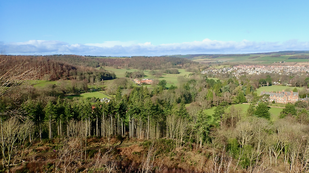
As well as my usual blue pin, from where I took the photo, I have added four others:
-
- Yellow – the site of the old village of Hooton is east of the 19th-century school house and is now entirely private gardens. In the photo, the rooftops of the old school can be seen just left of centre above the tops of the trees.
- Gold – the 18th-century manorial hall of Hooton is in an area of dense woodland north of the Public Footpath and mostly on private land. Apparently some old stones remain but I haven’t looked.
- Violet – this is Pease’s palatial Hutton Hall built in 1866/7. Extreme right in the photo.
- Green – on the 1782 estate map there is a settlement called Hooton Green. I’ve located it on the sledging field. The obvious place to build would be on the lower flatter part but the building of the railway will have obliterated any remaining humps and bumps. This is visible in the photo to the left.
- 1Dixon, Grace. “Two Ancient Townships – Studies of Pinchinthorpe and Hutton Lowcross”. ISBN 0 9507827 2 6 1991
Leave a Reply