
I have long been interested in ancient transport routes across the moors, so I was pleased to come across some recent research on routeways in the North York Moors1Stapley, D. 2025 Towards an Archaeology of Routeways: A case study from the North York Moors National Park, Internet: Archaeology 69. https://doi.org/10.11141/ia.69.7. These are vast landscape features, part of a tangled network linking places across great distances. Yet they are also intimate spaces, shaped by footfall, hooves, wheels, and centuries of human use. They carry more than people; they carry meanings—legal, social, historical. One form these routes can be detected is the hollow way.
The research mentioned one such feature: Pannierman Pots, an old sunken track still used as a public bridleway. It is described as a path with steep banks on either side. The report suggests “Pots” here may mean “pits” or “potholes,” referring either to natural features or damage left by the heavily laden panniermen2Stapley, D. 2025 Towards an Archaeology of Routeways: A case study from the North York Moors National Park, Internet: Archaeology 69. https://doi.org/10.11141/ia.69.7. Either way, the name hints at a direct link between people and place. I found it marked on the 19th-century map in an area I think I have only visited once, years ago. It felt worthy of a return.
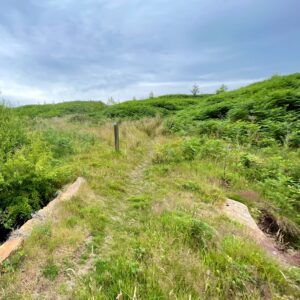
The approach followed another hollow way, following the parish boundary between Newton Mulgrave and Mickleby3NYMNPA HER No: 19199. Parish boundary between Newton Mulgrave and Mickleby. Routeway project nos: 183/4.. It is not a well-used path—often obliterated with gorse and bracken—but there were signs of horse traffic. As for the Pannierman Pots, they were underwhelming. A short sunken path leading to a stream, choked with vegetation. Any notable landform had been swallowed by bracken and second-growth woodland.
I carried on, hoping for more. A leaning stone, named—maybe with some justification—as Long Stone on old maps. It probably marked a boundary in the post-medieval period4NYMNPA HER No: 5521. Long Stone in Newton Mulgrave Woods.. When it once stood straight, it would have been tall by local standards. Hidden in a dense conifer plantation, finding it stirred memories of “bingo” controls from my early orienteering days.
The return leg, a straight line across Newton Mulgrave Moor, proved to be not the best of route choices. Tussocks and heather everywhere. But no going back once committed. Still, it was a good day to be out.
- 1Stapley, D. 2025 Towards an Archaeology of Routeways: A case study from the North York Moors National Park, Internet: Archaeology 69. https://doi.org/10.11141/ia.69.7
- 2Stapley, D. 2025 Towards an Archaeology of Routeways: A case study from the North York Moors National Park, Internet: Archaeology 69. https://doi.org/10.11141/ia.69.7
- 3NYMNPA HER No: 19199. Parish boundary between Newton Mulgrave and Mickleby. Routeway project nos: 183/4.
- 4NYMNPA HER No: 5521. Long Stone in Newton Mulgrave Woods.
Leave a Reply