
My trusted weather source, yr.no, claimed with confidence that rain would begin at noon. The climb from Guisborough had been hot and close under a humid sun. At 11:50, standing on Potter’s Ridge, the sky had turned grim. A few minutes later, the rain came — sudden, heavy, and, in truth, rather welcome.
I had always assumed dogs were banned from Open Access Land. However, a Government website suggests otherwise: dogs are allowed, provided they are kept on leads no longer than two metres from 1 March to 31 July, and at all times near livestock. Fair enough. The time limit protects ground-nesting birds — grouse among them. So, at other times, and far from sheep, dogs may roam free. That said, the wording is vague enough for a lawyer to argue that a sheep over the horizon counts as “near” and a grouse may or may not be “livestock”1Rights of way and accessing land. Gov.uk. https://www.gov.uk/right-of-way-open-access-land/use-your-right-to-roam#:~:text=Dogs%20on%20open,or%20assistance%20dogs..
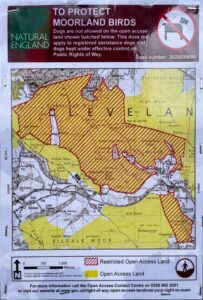
What did surprise me was discovering that a large area of moorland up here has a stricter rule: no dogs on the Open Access Land at all, lead or no lead. This rule stands until 2030. The reason? Grouse disturbance2CROW & Coastal Access Maps. Case number: 2020039098. https://experience.arcgis.com/experience/497afccfbe7a4db6884b8bedd23121f5/page/Business-Page?views=Map-Key-%2CRestrictions-%26-Exclusions#data_s=id%3Awidget_48_output_config_3%3A0.
It makes no difference to me now. Our dog has moved on to whatever moor lies beyond. Still, I cannot see why this moor, above all others, needs this extra restriction. And why are guide, hearing, and assistance dogs exempt? Are grouse less disturbed by dogs with a purpose? None of it adds up.
- 1Rights of way and accessing land. Gov.uk. https://www.gov.uk/right-of-way-open-access-land/use-your-right-to-roam#:~:text=Dogs%20on%20open,or%20assistance%20dogs.
- 2CROW & Coastal Access Maps. Case number: 2020039098. https://experience.arcgis.com/experience/497afccfbe7a4db6884b8bedd23121f5/page/Business-Page?views=Map-Key-%2CRestrictions-%26-Exclusions#data_s=id%3Awidget_48_output_config_3%3A0
Leave a Reply to John Cancel reply