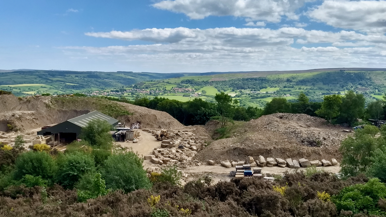
Wonderful views of the lower Esk Valley and the wooded Iburndale, but this large sandstone quarry took me by surprise. I had no idea it even existed, hidden from the A171 by woodland.
But what connects this quarry with an English diarist, a mole, and the first English colony?
According to one report I read there are only two quarries still operating in the North York Moors, Lowther’s Crag across the Esk above Grosmont, and here at Aislaby. Both work the sandstones known as the ‘Aislaby Stone’ or ‘Saltwick Sandstone’ (these terms are effectively synonymous and are often used interchangeably), and are considered the best quality building stone1BGS Report, Mineral Safeguarding Areas for North York Moors National Park Authority, Minerals and Waste Programme Commissioned Report CR/13/073 2013. ‘Saltwick Sandstone’ has been widely used throughout the North York Moors, including at Mount Grace Priory, Rievaulx Abbey, and Byland Abbey.
In 1632, Sir Hugh Cholmley, the Elder, Lord of the Manor of Whitby, with the assistance of the Earl of Stratford, procured a general contribution throughout England towards the construction of an harbour at Whitby. Huge blockstones were hewn from the outcrop and dragged down to Whitby by oxen to construct the harbour. In subsequent centuries, Aislaby sandstone was exported for the piers at Margate and Ramsgate, Convent Garden, as well as for the foundations of the Strand bridge, the precursor to Waterloo Bridge. In 1847 alone, 27,424 tons of ‘blockstones’ were shipped out of Whitby2Information plaque, Aislaby village. Located at Latitude: 54° 27’ 54.318” N, Longitude: 0° 41’ 9.06” W, 12th June 2021.
But sandstone was not Aislaby’s only export. In 1661, England acquired Tangier on the north coast of Africa as part of the dowry of Catherine of Braganza to King Charles II. It is considered to be England’s first colony3Margarette Lincoln. “Samuel Pepys and Tangier, 1662–1684.” Huntington Library Quarterly, vol. 77, no. 4, 2014, pp. 417–434. JSTOR, www.jstor.org/stable/10.1525/hlq.2014.77.4.417. Accessed 12 June 2021.. Charles’s plan was to create a ‘free port’ which would involve the building of a ‘mole’, a huge breakwater, 438 m long to create a deep harbour4Wikipedia Contributors. 2021. “Mole (Architecture),” Wikipedia (Wikimedia Foundation) <https://en.wikipedia.org/wiki/Mole_(architecture)#English_Tangier> [accessed 12 June 2021].
Samuel Pepys, the diarist, was appointed to the Tangier Committee charged with carrying out the King’s wishes, and he asked for Sir Hugh Cholmley, the Younger, to be the Director of Works, saying “he is a man that I love mightily as being a gentleman, the most industrious that I ever saw“5Information plaque, Aislaby village. Located at Latitude: 54° 27’ 54.318” N, Longitude: 0° 41’ 9.06” W, 12th June 2021. Cholmley took with him eleven skilled men from this area to be the foremen masons in charge of building the Tangier Mole6Wikipedia Contributors. 2021. “English Tangier,” Wikipedia (Wikimedia Foundation) <https://en.wikipedia.org/wiki/English_Tangier#The_Mole> [accessed 12 June 2021].
Within a couple of decades, Tangier had run into trouble. Parliament was concerned about the cost of maintaining the garrison, and a crippling blockade by Moroccan forces finally forced the English to withdraw in 1683. The King had given secret orders to abandon the city, level the fortifications, destroy the harbour, and evacuate the troops. The evacuation was witnessed by Pepys who wrote an account of it7Information plaque, Aislaby village. Located at Latitude: 54° 27’ 54.318” N, Longitude: 0° 41’ 9.06” W, 12th June 2021.
- 1BGS Report, Mineral Safeguarding Areas for North York Moors National Park Authority, Minerals and Waste Programme Commissioned Report CR/13/073 2013
- 2Information plaque, Aislaby village. Located at Latitude: 54° 27’ 54.318” N, Longitude: 0° 41’ 9.06” W, 12th June 2021
- 3Margarette Lincoln. “Samuel Pepys and Tangier, 1662–1684.” Huntington Library Quarterly, vol. 77, no. 4, 2014, pp. 417–434. JSTOR, www.jstor.org/stable/10.1525/hlq.2014.77.4.417. Accessed 12 June 2021.
- 4Wikipedia Contributors. 2021. “Mole (Architecture),” Wikipedia (Wikimedia Foundation) <https://en.wikipedia.org/wiki/Mole_(architecture)#English_Tangier> [accessed 12 June 2021]
- 5Information plaque, Aislaby village. Located at Latitude: 54° 27’ 54.318” N, Longitude: 0° 41’ 9.06” W, 12th June 2021
- 6Wikipedia Contributors. 2021. “English Tangier,” Wikipedia (Wikimedia Foundation) <https://en.wikipedia.org/wiki/English_Tangier#The_Mole> [accessed 12 June 2021]
- 7Information plaque, Aislaby village. Located at Latitude: 54° 27’ 54.318” N, Longitude: 0° 41’ 9.06” W, 12th June 2021
Leave a Reply