Alec E. F. Wright (1900 – 1981) was a local artist whose formative years were between the wars. His work is described as surrealist1@Artlandapp. (2022). Artland – Discover and Buy Art Online. [online] Available at: https://www.artland.com/artists/alec-ef-wright [Accessed 20 Apr. 2022].; some can be browsed here.
I hadn’t realised it but Wright drew the maps for Bill Cowley’s book of the Lyke Wake Walk, a copy of which I have had on my shelves for 55 years.
Wright was also a regular contributor to the Cleveland Standard, a local newspaper, writing about his rambling in North Yorkshire.
In the 25 August 1934 edition, he described a circular walk from Guisborough via Sleddale and Kildale before dropping down to Lonsdale Farm![]() 2THROUGH THE BONNY PURPLE HEATHER. | Cleveland Standard | Saturday 25 August 1934 | British Newspaper Archive. [online] Available at: https://www.britishnewspaperarchive.co.uk/viewer/bl/0003490/19340825/178/0008 [Accessed 19 Apr. 2022].:
2THROUGH THE BONNY PURPLE HEATHER. | Cleveland Standard | Saturday 25 August 1934 | British Newspaper Archive. [online] Available at: https://www.britishnewspaperarchive.co.uk/viewer/bl/0003490/19340825/178/0008 [Accessed 19 Apr. 2022].:
“A quick return to Guisborough can be made by continuing along this road, joining the Hutton road at Percy Cross. We, however, shall branch off into the fields on the left. The track runs by the edge of the wood, then bears right by two cottages and right again by a deep-hidden pool, beloved of the solitary swimmer. The path now enters a heather-clad valley, eventually reaching Great Ayton Station. This valley is Lonsdale, anciently known as Golstandale.”
This assertion that Golstandale was an early name for Lonsdale, probably comes from Ord’s History and Antiquities of Cleveland in a translation of the foundation Charter for Guisborough Priory3Ord, John Walker. “The History and Antiquities of Cleveland: Comprising the Wapentake of East and West Langbargh, North Riding, County York.” 1846. Available online at https://books.google.co.uk/books?id=qPsnAAAAYAAJ&dq=ord&pg=PA122#v=onepage&q=highcliffe&f=false, but it is far from clear and has resulted in much local debate4TURTON, MAJOR R. B. “A FEW CLEVELAND PLACE NAMES”. CLEVELAND NATURALISTS’ FIELD CLUB. RECORD OF PROCEEDINGS 1928 TO 1932. VOL.IV. Part 2.. Another source puts Golstandale in Commondale township5British-history.ac.uk. (2022). Parishes: Guisborough | British History Online. [online] Available at: https://www.british-history.ac.uk/vch/yorks/north/vol2/pp352-365#:~:text=Bridge%2C%20%27Hinderscoh%27%20and%20%27-,Golstandale,-.%27%20The%20following%20places [Accessed 20 Apr. 2022]..
But what really interests me about Wright’s piece is his description of his route along Lonsdale:
“We, however, shall branch off into the fields on the left. The track runs by the edge of the wood, then bears right by two cottages and right again by a deep-hidden pool, beloved of the solitary swimmer.”
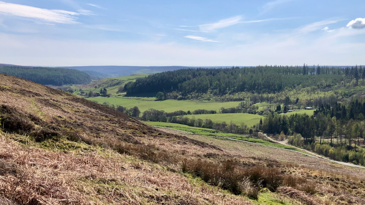
In the photo, Lonsdale Farm is in the distance, just left of centre. From there the earthwork of a track can be made out, crossing the field then following the edge of the forestry, to Lonsdale Cottages![]() , partially hidden by trees. An access track from there joins the tarmac road.
, partially hidden by trees. An access track from there joins the tarmac road.
This I think is the route that Wright, and other readers of his article, would have taken that summer in 1934. It is best followed on the 1930 Ordnance Survey map, which unfortunately is on two sheets, here and here.
The “deep-hidden pool, beloved of the solitary swimmer” would be the old flood whinstone quarry known as the Donkey Pond![]() .
.
This route taken by Wright has been included as a ‘Lost Path’ by the Ramblers ‘Don’t Lose your Way’ project, a campaign to get footpaths and bridle way that were missed off the Definitive Maps of 1949 added. (You will need to register to view this and navigate to the area.)
If this campaign is successful, it’ll be a great addition to the path network in Lonsdale.
- 1@Artlandapp. (2022). Artland – Discover and Buy Art Online. [online] Available at: https://www.artland.com/artists/alec-ef-wright [Accessed 20 Apr. 2022].
- 2THROUGH THE BONNY PURPLE HEATHER. | Cleveland Standard | Saturday 25 August 1934 | British Newspaper Archive. [online] Available at: https://www.britishnewspaperarchive.co.uk/viewer/bl/0003490/19340825/178/0008 [Accessed 19 Apr. 2022].
- 3Ord, John Walker. “The History and Antiquities of Cleveland: Comprising the Wapentake of East and West Langbargh, North Riding, County York.” 1846. Available online at https://books.google.co.uk/books?id=qPsnAAAAYAAJ&dq=ord&pg=PA122#v=onepage&q=highcliffe&f=false
- 4TURTON, MAJOR R. B. “A FEW CLEVELAND PLACE NAMES”. CLEVELAND NATURALISTS’ FIELD CLUB. RECORD OF PROCEEDINGS 1928 TO 1932. VOL.IV. Part 2.
- 5British-history.ac.uk. (2022). Parishes: Guisborough | British History Online. [online] Available at: https://www.british-history.ac.uk/vch/yorks/north/vol2/pp352-365#:~:text=Bridge%2C%20%27Hinderscoh%27%20and%20%27-,Golstandale,-.%27%20The%20following%20places [Accessed 20 Apr. 2022].
Leave a Reply